|
Penang Hills and Trails - Rimba Ridge |
|||||||||||||||||||||||||||||||||||||||||||||
|
This is one of a series of pages on walking the hills of Penang, click here for the index. This is a Grade 3 walk owing to the steepness of some the ascents / descents. There is a sketch map at the bottom showing the route followed. Click here for a list of the known PBA rain gauges. See also Rimba Ridge Revisited which has an alternative climb but the same descent. Please visit my Penang buses page for information on accessing the starting point. IMPORTANT By December 2023, the route from the Bayview Beach Hotel towards the Batu Ferringhi Reservoir past the 'Chin Farm' had been aggressively blocked by razor wire in the area where there is a gate by the water tank. There are also numerous signs stating "NO TRESPASSING - NOT A PUBLIC HIKING TRAIL" This will mean that there is no longer any access to / from any of these well known paths: 1. That to the Rimba at Teluk Bahang I do not know about current access through the main gate to the aqueduct above the former Holiday Inn. A month or so earlier, I had climbed Bukit Laksamana starting at the Rimba Forest Park in Teluk Bahang. It was hard work but it did suggest that turning left at the top of the first climb and proceeding to Batu Ferringhi might be a very pleasant hike and so it turned out, much better than the alternative route in the opposite direction which we had followed three years earlier. I have to confess that another one of my motivations was to collect a few more PBA rain gauges along the way... We're due to fly home to the UK soon and at the moment we don't have bus cards, so catching a 101 direct to Escape and walking on to the starting point was a good idea. You're meant to register before hiking but the chances of a member of staff rushing out and accosting you if you don't is vanishingly small. They are all in their air conditioned offices playing with their smart phones and counting the days till their next salary payment. Just follow the main road up bearing slightly right, continuing on the steps and then up following a pipeline. There are many other signposted paths here particularly to the left.
There was a surfeit of signs, we wanted 'Bukit Bendera' or 'Trail 4' at this stage.
Sometime ago the state forestry department had installed a job lot of ropes. For the most part they just get in the way, but sometimes on a day which was still, hot and extremely humid they were something of a comforter.
It's impossible to miss the fact that you have arrived at an initial summit, too much information! Last time I had been dragged up here in an hour, today was a more stately 90 minutes. We turned left and for the time being followed Trail 4.
Of course, all three paths from here lead down, but the square stone was a reassurance that we were on a water conservancy path.
When I suggested that the climbing for the day was over, I should have inserted the word 'major' but the path soon levelled out.
Soon we got to RG 21 which by coincidence was also the 21st I had recorded (out of 35 known). Unlike one later in the day, this one is unmissable. Around the corner a tree was down but it was easily skirted on the left.
It certainly was down or level all the way from here. Very occasionally this plastic crap is helpful but by and large it just makes me wish that the perpetrators would strangle themselves with the stuff. This announced a minor path to the left.
It was time to say goodbye to the Rimba trails and we continued straight on at the next T junction. One piece of plastic was more than enough to announce the existence of the ridge path.
Easy decision time, the plastic went left on a minor path, we followed the major path right and down a ridge on the basis that we needed to head for Batu Ferringhi.
Some moron had been spraying '39' on trees and then confirmation that we had made the right choice as we came upon RG 15 as expected.
It was lunch time but sunny so we we went on. We didn't know it at the time but when we stopped it was just before the path got significantly steeper.
It was hardly surprising given the length of time we had been climbing earlier.
It was hardly difficult until we came to a tree down. In this case somebody had decided to block the path, obviously at this point in our hike it didn't affect us, but someone coming the other way may have been discouraged from proceeding.
We could hear the stream below us and there was just one more nasty obstacle, a short drop down to a point from where we could see the Batu Ferringhi dam.
Of course for us it was obvious how to get out. For someone coming the other way, they would have to cross the rocky stream bed below the dam, note the sign and plunge into the ferns. In fact a left turn is needed and a climb up as indicated. We do NOT recommend following the signs as we had done on a previous occasion which follow the stream instead of climbing the ridge.
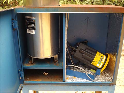
At this point I needed to do some exploring as Larry Malay had tipped me off as to where to find RG 16. It turned out from where we were the quickest way was to go up the concrete road and climb up a narrow (easily missed) path on the right at the first bend. An easier route in is from the bottom end of the upper aqueduct opposite the leaf filter (lower right photo).
Unusually, the metal box had no lock so I could view the logger and its battery, naturally I touched nothing and closed it afterwards. On the logger, the upper characters appear to be traditional Chinese and the lower ones 'DIK' plus Korean (there is a company called DIKmeasure). It was manufactured in 2007. Primayer is a UK company specialising in data logging applications involving water. Anecdotally, the PBA has had problems with them especially the batteries, no doubt the extreme heat in the day time in Penang will not help. As I have seen many of these modern boxes are empty and out of use. I do wonder how many are active these days, this one presumably is.
My provisional estimate of 4 hours for the main walk had been slightly exceeded even before this diversion. Afterwards we walked down past the Chin Farm and all the associated dumped rubbish and caught the bus home. Overall it had been a great success in an area we do not normally frequent.
|